Missouri Trailblazing
Your Guide to Missouri's Horse Trails and Camping
Route 66 Trail
Route 66 State park
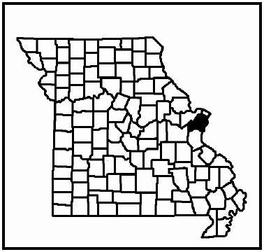
Location:
St. Louis County
News, Updates, & Warnings:
Nothing at this time.
Directions:
From St. Louis: takeInterstate 44 west. Exit at Route 109. Turn left, go under bridge and get back on I-44. Go 1 mile to Exit 265/Williams Road. Take the first left on the South Outer Road. Continue past the car dealership and you will be in the park. The equestrian parking lot is on the right near the end of the outer road.
To exit Route 66 SP: Enter Interstate 44 east at Williams Rd. If your destination is west, exit at the next exit, Lewis Rd, turn left and cross over the interstate, and turn left again to get back onto Interstate 44 westbound.
Miles of Trails:
7.5 miles in multiple loops.
Equestrian Camping:
Not Allowed.
Trail Notes:
Extremely easy, single track corridor mixed with road riding within the park. Almost perfectly flat through most of the park. Much of it is chip and seal surface so it‘s good for wet weather riding. It’s also a great place to start your horse out at the beginning of the riding season to get into shape. There are few hazards to watch out for: bike riders and people out for a walk, many with kids andstrollers, you‘ll ride around traffic, under the I-44 bridge, along side of I-44, and along side an active railroad track. Lots of deer and turkey here.
Other Trail Users:
Hikers and bike riders.
Volunteers Helping With This Page:
No one at this time, available to adopt. If interested, please contact us.
Photos:
Coming ASAP.
